Maps For Application

Boston Maps v.1.1.0.0
This app contains offline public (no data connection necessary after first download) transportation maps for the Boston area. Includes subway commuter rail commuter boat water taxi Boston detail maps MBTA system maps Can be used in portrait or

Chicago Maps v.1.0.0.0
Offline (no data connection necessary!) public transportation maps for the Chicago area. Click on the thumbnails and zoom in for a detailed look. Includes: 1. an overview of the Chicago Transit Authority system with the ability to zoom into

Leisure maps v.2.9.0.0
Maps for walking / cycling / exploring the great outdoors Download gpx or loc files to display routes or points of interest (including geocache locations). Display your position and track showing where you've been using a choice of map suppliers:

Philadelphia Maps v.1.0.0.0
Ad-free, offline (no data connection necessary after first download) public transportation maps for the Philadelphia area. Includes: subway commuter rail trolleys Can be used in portrait or landscape

Prague Maps v.1.0.0.0
This app contains offline (no data plan/reception necessary) public transportation maps for the Prague area, including tourist maps, metro/tram maps, and the Airport Express, which takes you from Prague Airport to popular the main train station,

Miami Maps v.1.1.0.0
Offline (no data connection necessary!) public transportation maps for the Miami Downtown area, including the Airport Flyer, which takes you from Miami Airport to popular South Beach. Zoom in for a detailed look. Includes: 1. an overview of the

National Park Maps v.1.0.0.0
Explore 15 of the top US National Parks with the best collection of trail maps available. National Geographic – THE place for maps – has opened up their best-selling, detailed Trails Illustrated National Parks Maps for download to your favorite

Chicago Maps Pro v.1.0.0.0
Offline (no data connection necessary!) public transportation maps for the Chicago area. Click on the thumbnails and zoom in for a detailed look. Includes: 1. an overview of the Chicago Transit Authority system with the ability to zoom into different
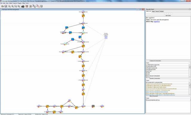
CytoSEED:Cytoscape plugin for Model SEED v.1.0
This project implements a Cytoscape plugin for viewing and manipulating pathway maps for metabolic models created by the Model SEED (http://www.
Animal Desktop Icons for Bada v.2013
This icon pack gets you a number of icons in high quality and resolution. They are good to be used for personal desktop customization, for application icons, web, or even toolbar icons.
IMapBuilder Interactive Flash Map Builder v.6.86
iMapbuilder is an interactive map program for Webmasters and anyone else who want to build professional, clickable, interactive maps for their web site, but is just too busy to learn Flash, programming or additional mapping software. Download

MyVietBanDo v.1.2.0.0
The primary text of the application is in Vietnamese. This map VietNam for Vietnamese in the world myVietBanDo application maps for Vietnamese Using data from vietbando.vn The main functions: - Map of Vietnam - Positioning - Find